
NavPad OG: Missionsrechner für das CockpitNavPad OG: mission computer for the cockpit
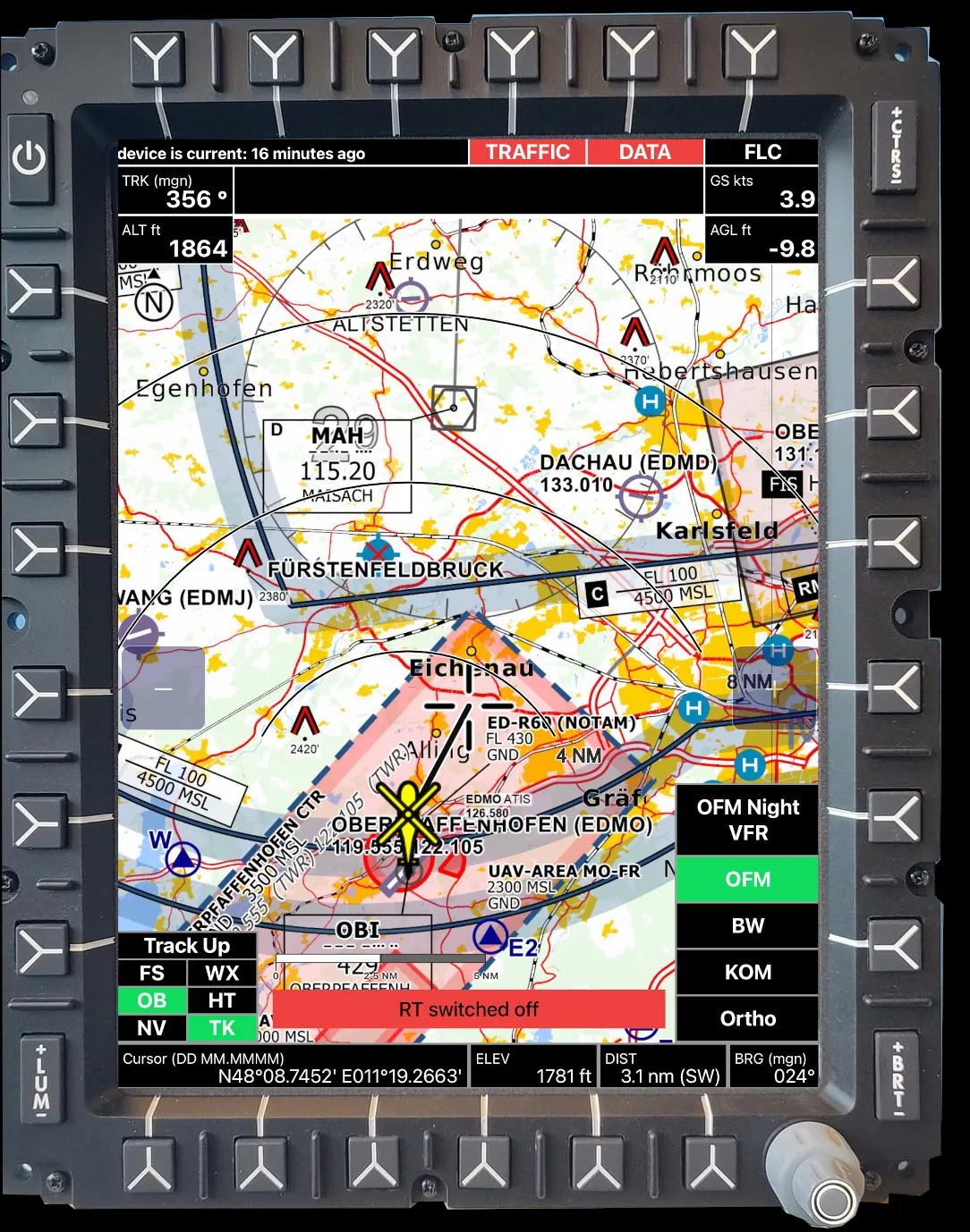
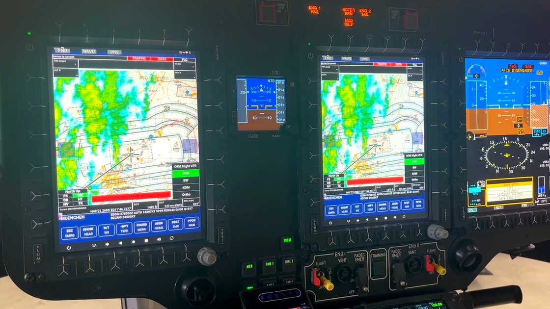
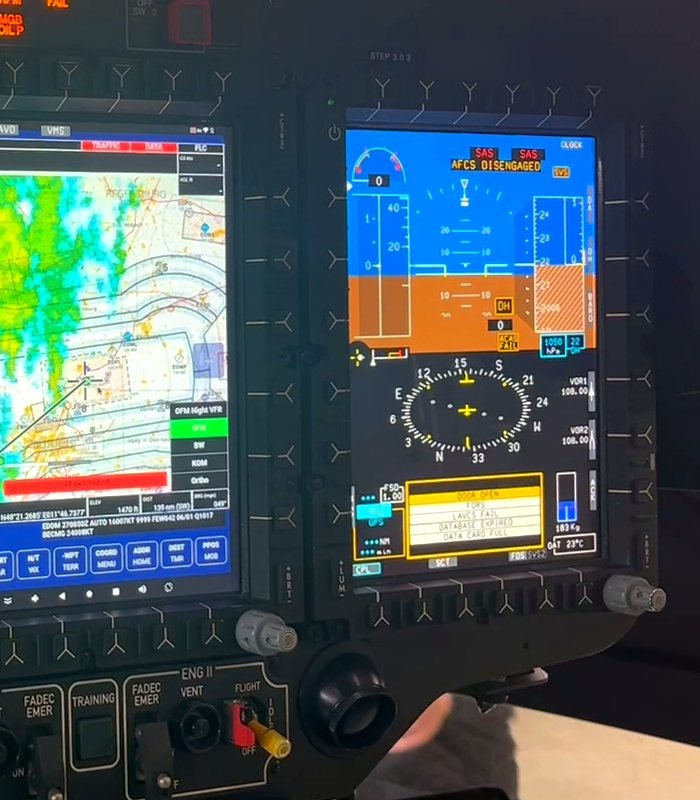
NavPad OG ist die Weiterentwicklung von NavPad. Die bewährte HEMS-Software läuft nicht mehr nur auf dem iPad, sondern als eigenständiger Missionsrechner nativ auf dem Airbus-Helionix-Cockpitdisplay. Offene Android-Plattform, Anbindung an den Avionik-Bus, taktische Funksteuerung und Updates over the air. Gemeinsame Entwicklung mit der ADAC Luftrettung. NavPad OG is the evolution of NavPad. The proven HEMS software no longer runs only on the iPad, but as a standalone mission computer, native on the Airbus Helionix cockpit display. Open Android platform, connection to the avionics bus, tactical radio control and over-the-air updates. Developed jointly with ADAC Luftrettung.
- GrundlageBasis
- NavPad, seit über 5 Jahren im HEMS-BetriebNavPad, in HEMS service for over 5 years
- ZielGoal
- eigene Avionik-Hardware, offene Android-Plattformproprietary avionics hardware, open Android platform
- DisplaysDisplays
- Airbus Helionix MFD
- EinbindungIntegration
- Avionik-Bus, taktischer Funk, VerkehrsfeedsAvionics bus, tactical radio, traffic feeds
- Updates
- Over the Air, im Flug, ohne AusfallzeitOver the air, in flight, no downtime
- StatusStatus
- in Entwicklung, Zulassung in Vorbereitungin development, certification in preparation
IdeeIdea
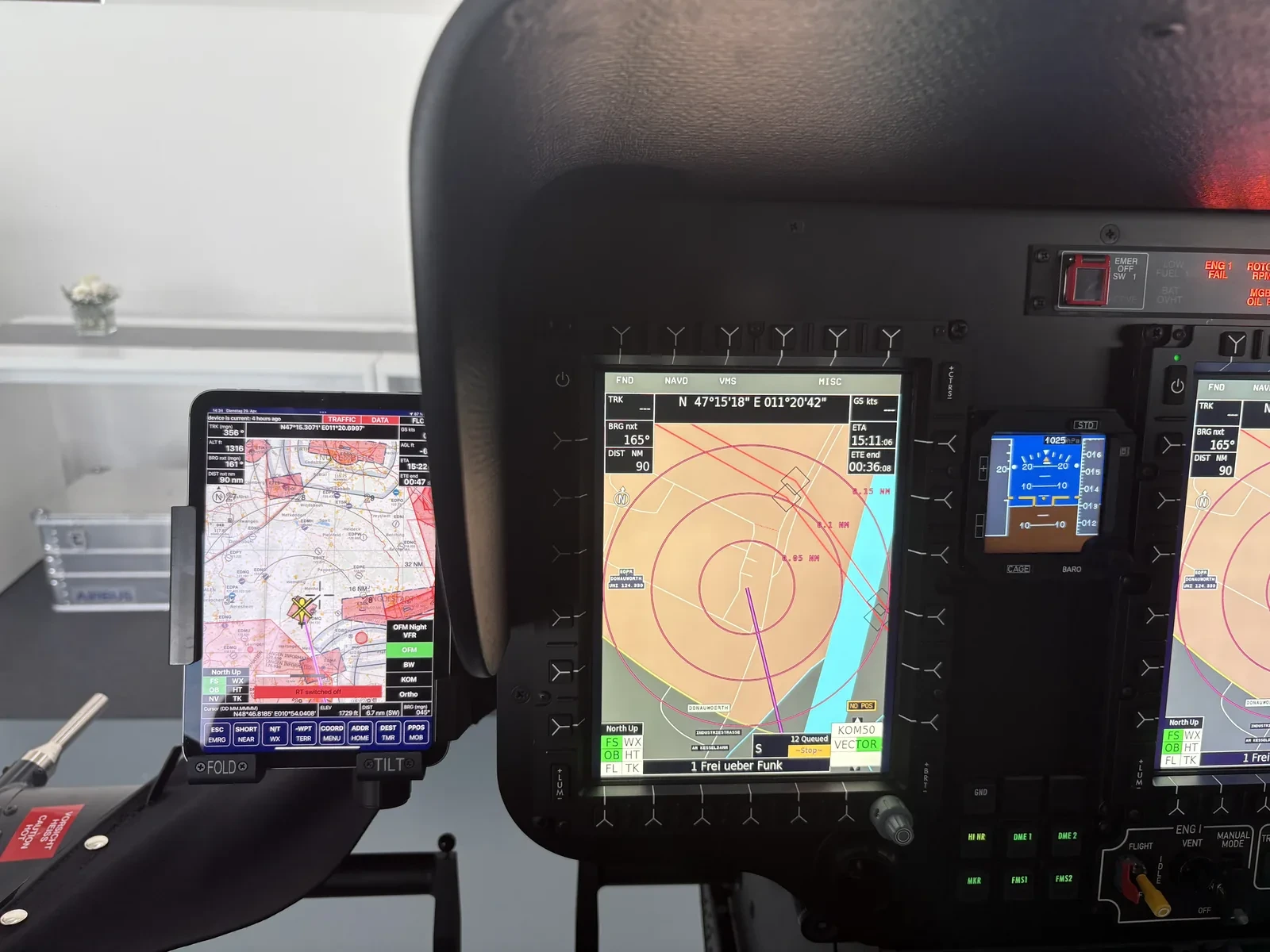
NavPad hat sich im täglichen Rettungsbetrieb bewährt. Der nächste Schritt bringt die Software vom mitgeführten Tablet in das fest verbaute Cockpitdisplay: als eigenständiger Missionsrechner, der Daten mit dem Avionik-Bus austauscht und über die vorhandenen Line-Select-Keys am MFD bedient wird. Kein zusätzlicher Bildschirm, kein separates Gerät im Sichtfeld. NavPad has proven itself in daily rescue operations. The next step moves the software from the carried tablet into the permanently installed cockpit display: as a standalone mission computer that exchanges data with the avionics bus and is operated via the existing line-select keys on the MFD. No extra screen, no separate device in the field of view.
PlattformPlatform
Eine ruggedisierte, passiv gekühlte Hardware mit offenem Android als Betriebssystem. Über einen offenen SDK lassen sich weitere Anwendungen und Plug-ins in den Missionsablauf einbinden, verwaltet über einen Mobile-Device-Management-Dienst. Verkehrsfeeds (ADS-B In, FLARM, TAS/TCAS, SafeSky) kommen mit Audiohinweisen ins Cockpit, die Anbindung an die Einsatzzentrale läuft über LTE und TETRA, und bis zu vier taktische Funkgeräte lassen sich gleichzeitig ansteuern. Ruggedised, passively cooled hardware running open Android as its operating system. An open SDK lets additional applications and plug-ins be integrated into the mission workflow, managed through a mobile-device-management service. Traffic feeds (ADS-B In, FLARM, TAS/TCAS, SafeSky) come into the cockpit with audio alerts, the link to the operations centre runs over LTE and TETRA, and up to four tactical radios can be controlled simultaneously.
VergleichComparison
Gegenüberstellung von NavPad OG und einem etablierten EMS-Rack-System, wie es heute in vergleichbaren Einsätzen verbaut ist. Angaben nach dem veröffentlichten Stand der Produktseite. Comparison of NavPad OG against an established EMS rack system, as fitted today in comparable operations. Figures per the published state of the product page.
| MerkmalFeature | NavPad OG | Etabliertes EMS-Rack-SystemEstablished EMS rack system |
|---|---|---|
| EingängeInputs | 2× MIL circ. · 8× ARINC 429 · 4× RS232 (Full-Duplex) · 4× Discretes · Audio (optional) · CAN-Bus · 2× Bedienpanel · Wi-Fi 6 / Bluetooth 5.x2× MIL circ. · 8× ARINC 429 · 4× RS232 (full-duplex) · 4× discretes · audio (optional) · CAN bus · 2× control panel · Wi-Fi 6 / Bluetooth 5.x | 7× D-Sub, für HEMS/VEMS überdimensioniert (Video-In, ARINC 429/708, RS232, RS485, Discretes…)7× D-Sub, oversized for HEMS/VEMS (video-in, ARINC 429/708, RS232, RS485, discretes…) |
| AusgängeOutputs | 2× SDI · 4× ARINC 429 · 4× RS232 · 2× Audio · HDMI (optional) · Discretes · ADC · I2C · CAN-Bus2× SDI · 4× ARINC 429 · 4× RS232 · 2× audio · HDMI (optional) · discretes · ADC · I2C · CAN bus | ähnlich, oft zu umfangreich oder veraltet für EMSsimilar, often overspecified or outdated for EMS |
| VerkehrssystemeTraffic systems | JaYes ADS-B In · FLARM · TAS/TCAS-I-Feed · SafeSky, inkl. AudioADS-B In · FLARM · TAS/TCAS-I feed · SafeSky, incl. audio | TeilweisePartial ADS-B In / TAS / FLARM, ohne AudioADS-B In / TAS / FLARM, no audio |
| Updates | OTA + MDM, im Hintergrund während des Flugs, ohne AusfallzeitOTA + MDM, in the background during flight, no downtime | nur per USB, Wartungsaktion am BodenUSB only, maintenance action on the ground |
| KartenCharts | eigene OFM-VFR- und Nacht-VFR-EMS-Karten · Gelände · frei definierbare Overlaysproprietary OFM-VFR and night-VFR EMS charts · terrain · freely definable overlays | unflexible Karten und Overlays, aufwendig zu pflegen und zu aktualisiereninflexible charts and overlays, costly to maintain and update |
| Rescuetrack | JaYes Full-Duplex zur Einsatzzentrale über LTE und TETRAFull-duplex to the operations centre over LTE and TETRA | kosten- und zeitintensiv über Iridiumcostly and slow over Iridium |
| Taktische FunkgeräteTactical radios | JaYes EMS-Bedienoberfläche zur Steuerung von bis zu 4 TETRA-Geräten gleichzeitigEMS control interface for up to 4 TETRA radios simultaneously | nicht vorgesehennot provided |
| HindernisseObstacles | JaYes aktuelle Leitungen · Masten · dynamische Datenbank · Warnungen (alle 5 min Prüfung auf neue Daten)up-to-date power lines · masts · dynamic database · warnings (checked for new data every 5 min) | TeilweisePartial statische Datenbank (28 Tage alt)static database (28 days old) |
| StartzeitBoot time | unter 20 s bis zur Moving Mapunder 20 s to the moving map | über 120 sover 120 s |
| AbmessungenDimensions | 170 × 170 × 70 mm | 200 × 360 × 60 mm |
| GewichtWeight | unter 1500 gunder 1,500 g | über 2,8 kg zzgl. Rackover 2.8 kg plus rack |
| ProzessorProcessor | 8-Kern-64-Bit-ARM (A76 · A55) bis 2,4 GHz (Android), NPU (KI bis 6 TOPS), ARM Cortex (430 MHz), DO-178-zertifiziert8-core 64-bit ARM (A76 · A55) up to 2.4 GHz (Android), NPU (AI up to 6 TOPS), ARM Cortex (430 MHz), DO-178 certified | ältere Prozessorarchitekturolder processor architecture |
| GrafikGraphics | ARM Mali-G610, bis 8K, Hardware-KartenrenderingARM Mali-G610, up to 8K, hardware map rendering | integrierte HD-Grafikintegrated HD graphics |
| ArbeitsspeicherMemory | 16 GB (LPDDR5), erweiterbar16 GB (LPDDR5), expandable | nicht spezifiziertnot specified |
| BetriebssystemOperating system | Android | Linux, nicht aktualisierbarLinux, not updatable |
| FlexibilitätFlexibility | JaYes offenes SDK · Plug-ins · eigene Layer · MDM-Serviceopen SDK · plug-ins · custom layers · MDM service | TeilweisePartial begrenzt, jede Funktion kostet extralimited, every function costs extra |
| BedienungControls | Bedienpanel + Fernbedienung + Line-Select-Keys am MFD, handschuhtauglich, flexibelControl panel + remote control + line-select keys on the MFD, glove-compatible, flexible | nur Bedienpanelcontrol panel only |
Missionsrechner oder Avionik-Integration für Ihren Betrieb?Need a mission computer or avionics integration for your operation?
Projekt anfragenStart a project